Lynx
Map AutoCAD Samples
The Lynx Map automation project was designed to aid the dispatcher by providing
an easy method for accessing the highly accurate Fire
Net Six digital map information. This information will be used
by the dispatcher to aid responding Fire and EMS units by providing picture
of where the incident is occurring.
The Lynx Map system has been fully integrated with our PRC CAD system.
One of the main goals of the project was not to give the dispatcher another
keyboard or mouse for them to operate. Dispatchers have enough work
to perform, without having to manipulate a second keyboard or mouse.
Features of the CAD/MAP integration include the following features:
-
Display with icon based on incident type, the selected event. This
is done by the dispatcher via a function key.
-
Pan the map up, down, left, and right.
-
Zoom the map in and out.
-
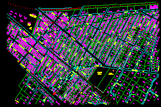
Turn on/off layers of information (house number, street name, hydrant,
etc.) based on zoom level. As the magnification factor decreases,
the level of detail becomes unreadable (as seen in the third image).
-
Redraw the screen (refresh)
-
Print the current map (future enhancement)
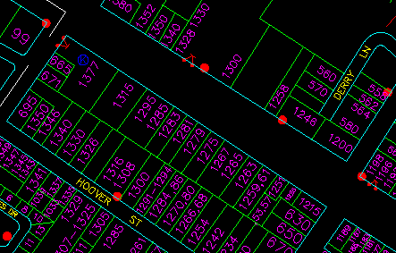
This is the first sample image of the digital map system. As you
can see, the detail and accuracy of the information is very high.
This is a small section of Redwood City at the default magnification factor.
 (Click on image to see the
larger image)
(Click on image to see the
larger image)
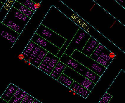
This second image is displayed at a much higher magnification factor then
the first image.
 (Click on image to see larger
image)
(Click on image to see larger
image)
The third image is the same area, but at a very decreased magnification
factor.
 (click on image to see the
larger image)
(click on image to see the
larger image)
Mapping System Hardware and Software:
-
Intel Pentium Pro 200 Mhz
-
128mb RAM
-
4gb SCSI hard disk drive
-
1gb SCSI JAZZ drive
-
12X SCSI CDRom drive
-
4mb Maxtron Mellimum video card
-
3COM ethernet 10base-T network card
-
20 inch ViewSonic monitor
-
HP DesignJet 350C color plotter
-
Windows NT Workstation 4.0
-
AutoCAD Map, Release 14
-
AutoLISP programming by LYNX Technologies
** Additional images will be posted as they become available and
as the project nears completion.
 Please send questions, comments
or bug reports to RSB@smc911dispatch.org
Robert Bustichi, Systems Management Unit
San Mateo County Public Safety Communications
401 Marshall Street
Suite EPS103
Redwood City, CA 94063
Phone: (415) 363-4342
Fax: (415) 363-1819
EMail: RSB@smc911dispatch.org
WWW: http://www.smc911dispatch.org
Please send questions, comments
or bug reports to RSB@smc911dispatch.org
Robert Bustichi, Systems Management Unit
San Mateo County Public Safety Communications
401 Marshall Street
Suite EPS103
Redwood City, CA 94063
Phone: (415) 363-4342
Fax: (415) 363-1819
EMail: RSB@smc911dispatch.org
WWW: http://www.smc911dispatch.org
Revision: 17-July-1997

